|
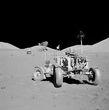
Apollo 17 astronauts repeated these temperature surveys and Apollo 16 and 17 crews also ran surface resistivity (EM style) surveys, similar to Conrad Schlumberger's early work in France back in the 1920's. The lunar results: "The Moon is very dry". Golly, who would have guessed that? But don't despair. The moon has been mapped for neutron absorption and some areas absorb neutrons better than others. Hydrogen, hydrocarbon, or water? Or some other absorber (like iron for example)? Who knows.
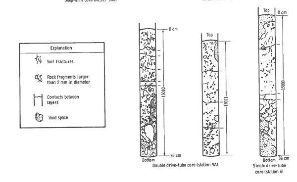
1971,as well as sketches of some core samples.
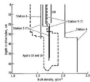
Apollo astronauts brought back 2415 samples of rocks, soils, and cores weighing 840 pounds from the sis Lander sites on the near side of the moon. Only 32 pounds have been thoroughly analyzed and another 30 pounds are on display around the world. The balance sits in a vault in Houston. No one has explained why more anlysis has not been done. Shallow cores were taken during Apollo 15, 16, and 17 missions. Rocks were also analyzed in-situ with X-Ray fluorescence and photography. Samples of rocks were returned to Earth and subjected to myriad tests, much as we have done for many years on Earth in the oil and mineral business. Sample lunar cores are illustrated below.
For more information:
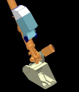
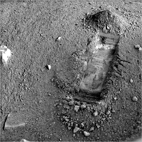
Phoenix was equipped with a miniature back-hoe (called the Robotic Arm or RA for short) to dig trenches and deliver soil samples to other experiments inside the space craft. The TECP probe was mounted on the pivot at the RA scoop so it could be pressed into the surface soil or the wall of a trench. TECP is the 4-pin
device above the Robotic Arm scoop near The TECP is adapted from the commercial KD-2 multi-purpose probe made by Decagon Devices. The four-pin probe determines electrical conductivity by a two-pin LC (dielectric constant) approach and a redundant four-pin van der Pauw technique. The 4 pin EC method is similar to the Schlumberger four electrode AMNB surface resistivity electrode arrangement from the early 1900's.
The primary purpose of the TECP was to measure the concentration and nature of water in Martian soils in solid, “non-frozen,” liquid, and vapor states. Other objectives were to determine changes in the reservoirs of water when soil is freshly exposed and to characterize the movement of water in and out of the soil by measuring atmospheric humidity, temperature, and wind speed above the surface. Sounds a lot like reservoir evaluation and monitoring.
There are hundreds of ASCII data files available with the results of the TECP measurements, recorded versus time and day of acquisition. None appear to have been plotted versus depth in the trenches that were dug by the robotic arm. However there are lots of images that are strikingly similar to resistivity microscanner images.
Phoenix was purposely placed on the Martian Arctic Plain. It is cold there, but not impossibly so - a mere 70 C colder than the Canadian Arctic Islands, where we have found more than 17 Tcf of natural gas. So who is ready to drill on Mars?
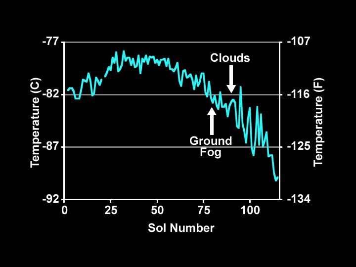
The meteorological station on Phoenix was designed to monitor changes in water abundance, dust, temperature, and other variables in the Martian atmosphere. The Canadian Space Agency, York University, University of Alberta, Dalhousie University, Optech, and the Geological Survey of Canada designed and monitored the science operations of the station, which was built by Canadarm maker MacDonald Dettwiler and Associates Ltd. of Richmond, B.C.
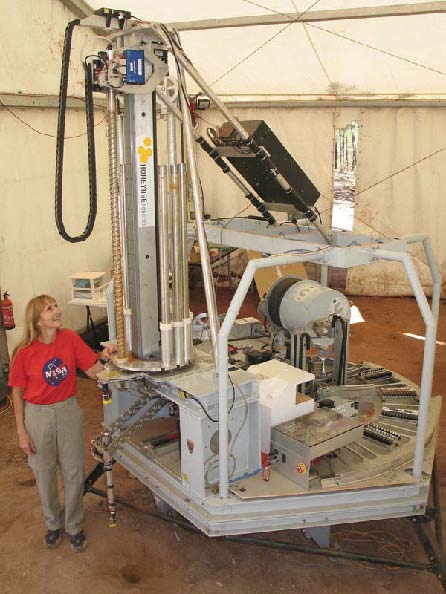
Prototype robotic
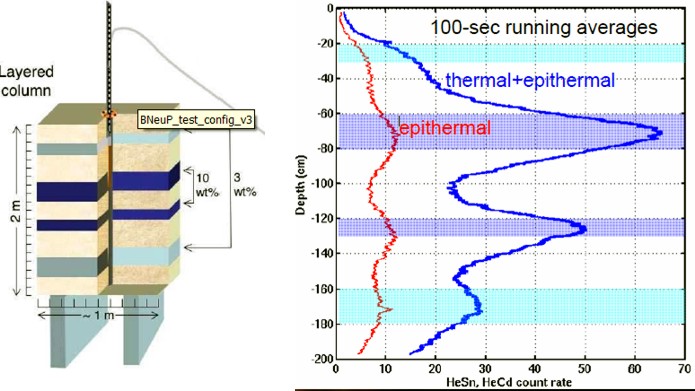
drilling rig for Mars The prototype robot drilling/coring/logging machine reached 10 meters. Plans for 100 meter capability are in the works. The objective is to advance the search for life on Mars, but where there is life, there is a possibility of hydrocarbons. There is methane in the Martian atmosphere and spectroscopy mapping indicates the presence of clay and carbonate rocks, as well as the more obvious lava, dust, and other sediments. Interested parties can apply HERE for drilling concessions. MARTE can drill, core, and run neutron and fluorescence logs. Neutron logs see water and ice; fluorescence logs see bacteria. The Ames tool is so sensitive, it can see a single bacterium. The core samples can be analyzed on the drilling platform, then stacked for future examination. The remote sensing core analyzer can face or saw core samples, run spectrography, and prepare powder samples. The borehole inspection system (BHIS) runs the neutron probe, a panoramic microscopic imager, and spectrometer. The borehole neutron log (BneuP) measures both thermal and epithermal neutron count rates. A surface version of the tool, to be carried on a Mars rover, is called (you guessed it) SneuP. It is intended as a dowsing machine, looking for hidden near surface water or ice deposits.
It's all real and
working (almost). We just have to get it there and get to work.
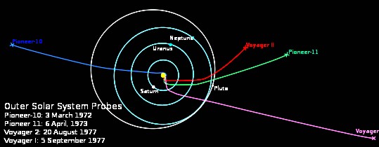
A log is a record of some observation versus time or distance, presented on an X-Y coordinate graph, a written narrative, or an audio or video report. Pilots, truckers. taxi-drivers, and tourists all keep logs. So do oil well drillers and other intrepid explorers who walk the Moon or operate robots on or near other planets. We even have logs from interstellar space. The Voyager 1 spacecraft, launched in Sept 1977, has recorded logs over the longest distances yet measured. The documented geological record of the Earth is the longest time-based record so far, unless you want to count the less-well documented history of the Universe beginning before the Big Bang.
All image credits: NASA/JPL
http://www.jpl.nasa.gov/ |
|||
|
Page Views ---- Since 01 Jan 2015
Copyright 2023 by Accessible Petrophysics Ltd. CPH Logo, "CPH", "CPH Gold Member", "CPH Platinum Member", "Crain's Rules", "Meta/Log", "Computer-Ready-Math", "Petro/Fusion Scripts" are Trademarks of the Author |
|||


|
||
| Site Navigation | HISTORY FIRST LOGS ON LUNA and MARS | Quick Links |
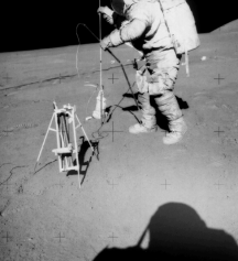
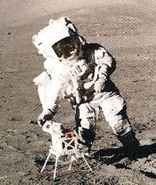 Harrison "Jack"
Schmidt deploying the Surface Electrical Properties equipment (SEP) during Apollo 17 mission, 1972.
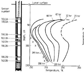
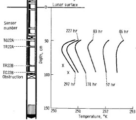
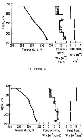
 The
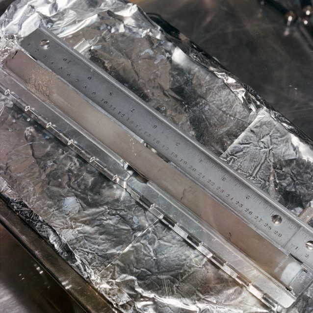
two drive-tube cores from Apollo 16 and 17 have never been seen by
human eyes. They were sealed in their tubes under the vacuum of the
moon and sealed in a second vacuum container at the vault in
Houston. These pristine samples await investigation by "more
sophisticated techniques" than are presently available. High
resolution core photos like the one at the left are at
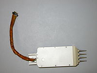 Thermal conductivity is measured by a
pulse-decay method using a heater and a thermocouple pair embedded
in the pins.
 After
Phoenix comes MARTE, a stratigraphic drilling program for Mars. Mars
Astrobiology Research and Technology Experiment (MARTE) performed a
field test simulating a robotic drilling mission on Mars in
September 2005. The experiment took place in Minas de Riotinto in
southwestern Spain, a highly relevant Mars analog site. The
experiment utilized a 10 m class dry auger coring drill, a robotic
core sample handling system, onboard science and life detection
instruments, and a borehole inspection probe, all of which were
mounted to a simulated lander platform.